Fragmented data
Landscape projects stay in CAD files, spreadsheets and paper; cities often do not know which tree stands in which park.
Tomorrow’s technology for tomorrow’s resilient cities

Urban Green Infrastructure and Climate Adaptation Operating System
YEKOS is an original system design. Its texts, visuals, interface, software and video are protected by copyright (Turkish Law No. 5846, Berne Convention) and may not be reproduced without permission. Contact us for licensing.
YEKOS — the Urban Green Infrastructure and Climate Adaptation Operating System. It does more than record a city's green assets: it turns each one into a smart, object-based digital asset, brings it to life in every scenario and delivers decision support from one shared intelligence.
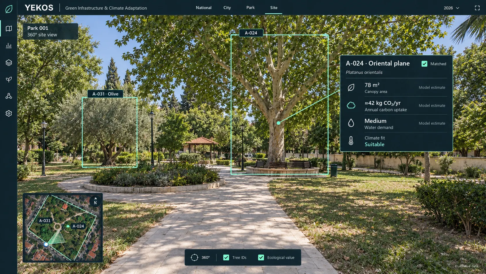
Trees and green spaces cool streets, return rainwater to the soil and groundwater, and store carbon. Yet no system turns these nature-based solutions into data. The result: wasted water, plants lost too early and public money spent again and again.
Landscape projects stay in CAD files, spreadsheets and paper; cities often do not know which tree stands in which park.
Without data, irrigation, species choice and maintenance follow habit: wasted water and plants lost too early.
The climate contribution of urban green is not measured with shared indicators, so it cannot be reported or targeted.
Cities struggle to become smart because their tools do not talk to each other. Like the operating system on our phones, YEKOS brings separate tools together in one core.
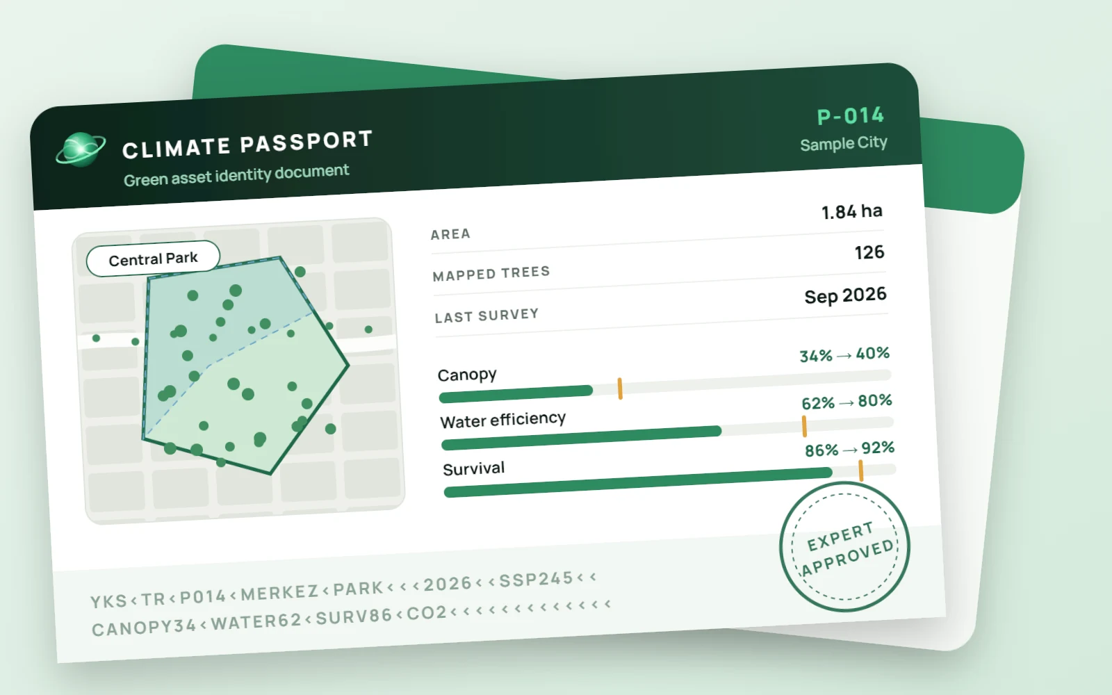
The ID card of every green space: assets, risks, water and shade status, targets and intervention history. Expert approved and updated every year.
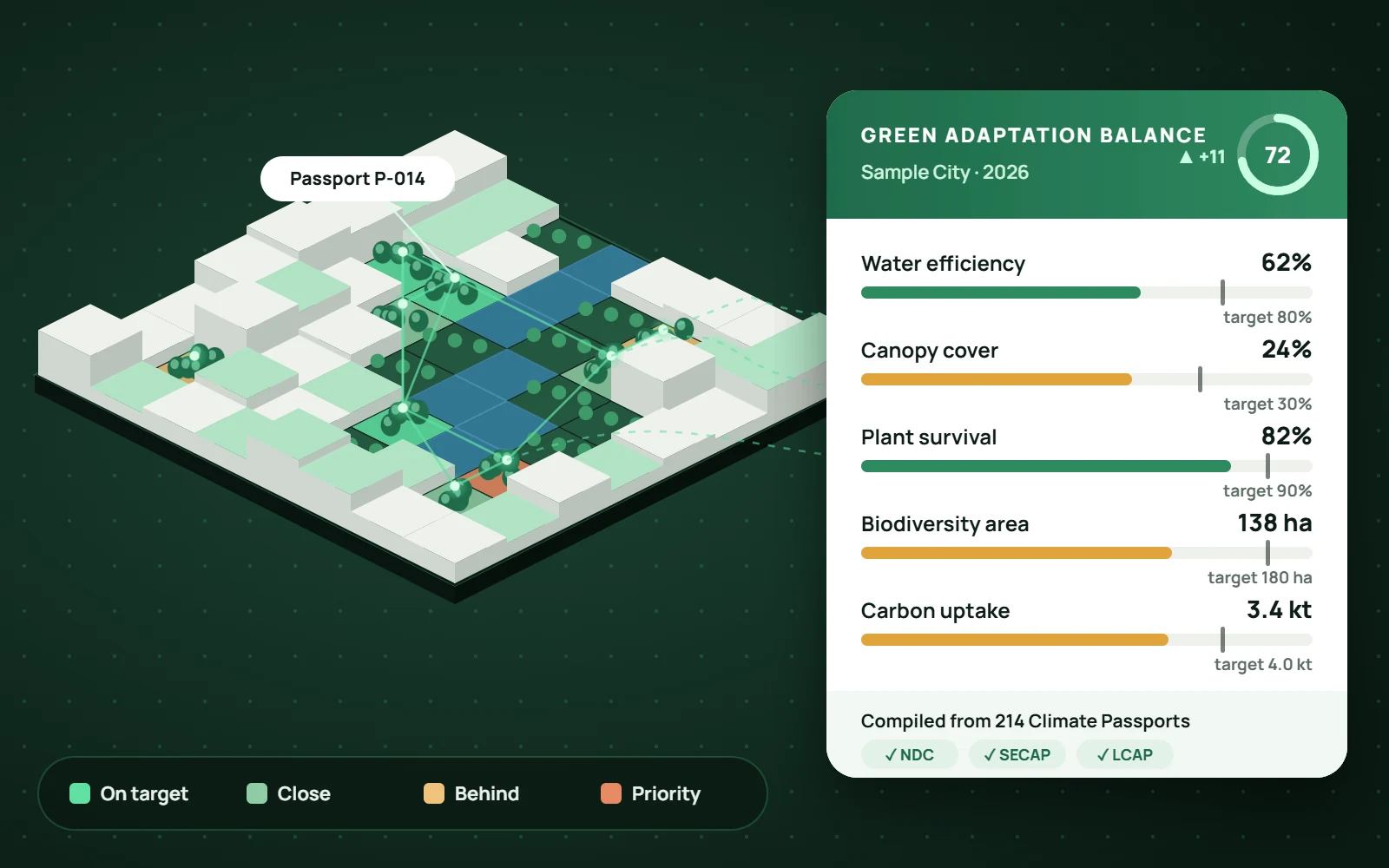
Built from the passports: the whole green network of parks, street trees and corridors, with baseline, targets and measured progress.
YEKOS is not a one-off inventory but a living system that keeps urban green data up to date and re-measures its own results.
Field app, drones and existing records.
Every green asset as a live digital object.
Water, shade, species, biodiversity, carbon.
Priorities and actions against city targets.
Approved tasks land on the crew's phone.
Results are measured; the twin is updated.
35+ main data layers in seven groups, seven analysis engines and seven outputs run in one core on open standards. Every green asset is an object; every result is stored with its source, method and version.
These are the main layers; open datasets are combined with the institution’s own records and new layers are added as each city needs. Model coefficients, decision rules and the YEKOS plant database are proprietary; details are shared with pilot partners under a confidentiality agreement.
GET /v1/assets/A-024{ "id": "A-024", "type": "tree", "species": "Platanus orientalis", "passport": "P-014", "canopy_m2": 78, "co2_kg_per_year": 42, "water_need": "medium", "climate_fit_2050": "suitable", "verified_by": "expert", "updated": "2026-09-14"}from yekos import Core, Scenariocity = Core.connect("sample-city") # on-premise serverpark = city.passports.get("P-014") # Climate Passportresult = park.simulate( Scenario.ssp("SSP5-8.5", year=2050), engines=["water", "shade", "species", "carbon", "stormwater"],)for action in result.recommendations(top=3): print(action.title, action.gain, action.confidence)Connects to existing GIS through GeoJSON and OGC services.
Data stays on the institution's own servers.
Every result is stored with its source, method and version.
Every recommendation carries a confidence level and an approval record.
Parks departments, climate units, field crews and management work on the same screen.
Plant clusters · tap to highlight
Data produced · Central Park, 126 trees
The ID card of every green space: assets, risks, water and shade status, targets and intervention history. Updated every year.
All green assets, risk areas and open tasks on one map, with tasks ranked by risk and target.
Compares the water, shade, carbon and cost impact of interventions such as irrigation, plant health, pollinator strips and rainwater before delivery, then sends them for expert approval.
Generated automatically from the passports: the city's baseline, target pathway, measured progress and reporting outputs.
The city's existing building, green space and tree data rise into 3D in seconds. Plants are clustered by species, health, water and climate fit; the city is coloured like an X-ray, so problem clusters stand out at a glance.
Data comes together in one core and flows into the analysis engines like signals: heat island, shade, water, species fit, biodiversity, carbon, stormwater and flooding. Each engine maps the city, and the results combine into priorities in decision support.
Drones, the mobile field app and import of existing inventories work together to digitise your city's green assets in the shortest time. The drone records every tree's species, height, canopy and coordinates through an orthophoto pass and a smart low flight between trees; records reach the Climate Passport after expert approval.
Screens are representative: simplified views and sample data are used to protect intellectual property.
Data enters at the bottom, gains value at every layer and leaves the top as decisions and reports. Each module delivers value on its own; all share one core and one data model. Every municipality and country runs YEKOS on its own servers: data stays home, indicators are shared.
KURAS is the water and climate suitability module of YEKOS. Inside YEKOS it works on the city's own inventory: it calculates location-specific water demand, winter hardiness and 2050–2100 climate suitability for every tree and plant, and feeds the results into irrigation zones, species recommendations, the Climate Passport and the Green Adaptation Balance Sheet. A public version of the module already runs at kurakcilanaliz.com.
Although olive is considered drought-tolerant, its water demand and winter hardiness vary markedly between provinces; a single guideline class is not enough for site-specific decisions.
Distribution across 81 provinces. Under high emissions, the number of provinces where this plant needs high water rises from 16 to 41 by 2100.
Source: KURAS · Gilik & Yılmaz (2026), preprint. Province centres; median of 15 CMIP6 models.
“This species needs high water here; move it to irrigation zone 3.”
“Winter risk under the 2050 climate; these species fit instead.”
A location-specific suitability report for every species (PDF and Excel).
For Türkiye: As drought and water stress grow, putting the right plant in the right place is the fastest way to save water. KURAS makes this check for every location with local climate data; national guidance expects these strategies to cut water use by 20–50%.
ERA5 climate data, the FAO-56 method and 15 CMIP6 models; built on global datasets, so it adapts to any country.
Preprints (Gilik & Yılmaz, 2026): doi.org/10.5281/zenodo.23436244 · doi.org/10.5281/zenodo.23436246A YEKOS scenario for an illustrative city with 1,000 hectares of irrigated green space. The counters show how the gains build up from 2026 to 2030.
Nature-based solutions are among the strongest answers to the climate crisis. By making their impact measurable, YEKOS puts landscape architecture and related professions at the heart of resilient cities.



YEKOS brings both together in one shared intelligence: expertise becomes measurable with data, and data gains meaning through experts.
The system proposes; design and decisions belong to the landscape architect. Every recommendation is approved by an expert and recorded under their name.
Once the cooling, water and carbon benefits of trees are measured, green space stops being a cost line; it is reported as a climate investment and earns its share of the budget.
Inventory, drone surveys, Climate Passport preparation, monitoring and verification create new roles dedicated to green infrastructure.
Repetitive measuring and calculating is automated, so experts can spend their time on design and in the field, where their expertise matters most.
COP31 puts the focus on turning climate targets into results on the ground. That is exactly what YEKOS does: it makes the climate contribution of urban green measurable, comparable and reportable.
An open framework of urban green indicators for water, shade, plant survival, biodiversity and carbon.
YEKOS in the first cities after COP31, with an inventory and the first Climate Passports by month five.
The common core adapted to other countries with local data packages, with comparable results.
To deliver measurable results in cities, we are open to partnerships in four areas.
Be one of the first cities to measure its green infrastructure.
Become the technology partner of measurable nature-based solutions.
Let's validate the methods together on real city data.
Let's build shared indicators together, from city to national reporting.
We discuss your needs and the data you already have.
A park or neighbourhood is chosen and existing records are imported.
Target: inventory and the first Climate Passports by month five.
Write to us to discuss YEKOS for your city, your organisation or at COP31.